Complete Solutions and Summary of Interior of the Earth – NCERT Class 11, Geography, Chapter 3 – Summary, Questions, Answers, Extra Questions
Explanation of the earth’s internal structure, sources of information for studying earth’s layers, details on crust, mantle, core, seismic waves, earthquakes, volcanoes, volcanic landforms, and intrusive igneous structures, using indirect and direct scientific evidence.
Updated: 8 months ago
Interior of the Earth
Chapter 3: Interior of the Earth - Ultimate Study Guide | NCERT Class 11 Notes, Questions, Examples & Quiz 2025
Full Chapter Summary & Detailed Notes - Interior of the Earth Class 11 NCERT
Overview & Key Concepts
- Chapter Goal: Understand earth's interior structure, sources of information, earthquakes, volcanoes, and landforms. Exam Focus: Direct/indirect sources, seismic waves, shadow zones, earth layers (crust, mantle, core), volcano types, intrusive/extrusive forms. 2025 Updates: Emphasis on seismic data analysis, plate tectonics links. Fun Fact: Earth's core is as hot as the sun's surface (~5500°C). Core Idea: Interior inferred indirectly via seismic waves, gravity, magnetism. Real-World: Earthquake prediction using seismographs. Ties: To chapters on landforms, plate movements, disasters.
- Wider Scope: Endogenic processes shape surface; human impacts via mining, drilling. Expanded: Earth's radius 6378 km; deepest drill 12 km (Kola). Layers: Crust (5-70 km), mantle (2900 km), core (liquid outer, solid inner). Seismic waves reveal discontinuities like Moho, Gutenberg.
- Expanded Content: Interior inaccessible directly; indirect evidences from volcanoes, meteors, gravity anomalies. Earthquakes release energy along faults; waves (P, S, surface) propagate differently. Shadow zones indicate liquid core. Volcanoes classify by eruption; landforms include batholiths, dykes. Human life influenced by physiography; tsunamis from oceanic quakes.
Introduction
Imagine earth as solid or hollow ball. Volcanic images show lava, dust, smoke. Interior understood indirectly; no direct access. Surface configuration from interior processes (endogenic) and external (exogenic). Physiography incomplete without endogenic effects. Human life influenced; know forces for landscape, earthquakes, tsunamis. Earth materials layered crust to core. Scientists gathered info on layers' characteristics. Expanded: Radius 6378 km; deepest mine 4 km, drill 12 km. Hot interior limits access; indirect via seismic, gravity.
- Examples: Volcanic crater magma; earthquake shaking.
- Point: Indirect evidences key; processes shape landscape.
- Expanded: Exogenic erode; endogenic build. Human adaptation to physiography; e.g., mountains tourism, plains agriculture.
Extended: Previous chapter layers; this details characteristics, sources. Why earth shakes: Energy release faults. Focus/hypocentre underground; epicentre surface.
Sources of Information About the Interior
Direct: Surface rocks, mining (3-4 km South Africa), drilling projects (Kola 12 km, Deep Ocean Drilling). Volcanic magma analysis; depth uncertain. Indirect: Temperature/pressure/density increase with depth; estimates from earth's thickness. Meteors similar composition. Gravity varies latitude/mass; anomalies indicate crust distribution. Magnetic surveys crustal materials. Seismic activity detailed. Expanded: Mining hot beyond 4 km; projects provide crustal samples. Meteors not interior but analogous. Gravity greater poles; anomalies from uneven mass.
- Examples: Kola drill Arctic; Integrated Ocean Drilling.
- Point: Mostly indirect; direct limited shallow depths.
- Expanded: Temperature 1°C/32m; pressure millions bars core. Density 3 g/cm³ crust to 13 core.
Extended: Gravitation, magnetic field, seismic waves. Gravity anomaly: Difference expected/observed; indicates subsurface.
Earthquake
Shaking from energy release; waves all directions. Along fault; rocks move opposite, friction locks, overcome slides. Focus/hypocentre release; epicentre surface nearest. Waves: Body (P primary fast, through all; S secondary solid only) and surface (destructive). Velocity changes density; reflect/refract. Propagation: P parallel compress; S perpendicular troughs/crests. Expanded: Lithosphere to 200 km quakes. Seismograph records; three sections waves. P like sound; S helped infer liquid core.
- Examples: Fault break; energy waves.
- Point: Seismic waves picture layered interior.
- Expanded: Vibrations: P density differences; S vertical plane.
Extended: Types: Tectonic (sliding faults), volcanic (active areas), collapse (mines), explosion (nuclear).
Emergence of Shadow Zone
Zones no waves recorded. P/S shadow 105-145° epicentre. S not beyond 105°; larger zone (40% surface). P band 105-145°. Draw for any epicentre. Expanded: Seismographs within 105° both; beyond 145° only P. Indicates liquid outer core (S can't pass liquid).
- Examples: Figure 3.2 a/b shadow zones.
- Point: Reveals interior structure.
- Expanded: S shadow entire beyond 105°; P partial.
Extended: Helps understand core composition.
Measuring Earthquakes & Effects
Richter magnitude 0-10 energy; Mercalli intensity 1-12 damage. Effects: Shaking, settlement, slides, liquefaction, lurching, avalanches, displacement, floods, fires, collapse, objects, tsunami. First six landforms; tsunami oceanic high magnitude. Expanded: Quake seconds; devastating >5 Richter. Tsunami not earthquake but waves from tremors.
- Examples: Aman Setu damage; tsunami photos.
- Point: Hazardous; immediate life/property concern.
- Expanded: Ground shaking collapses; liquefaction sinks buildings.
Extended: Frequency: 8+ rare 1-2 years; tiny every minute.
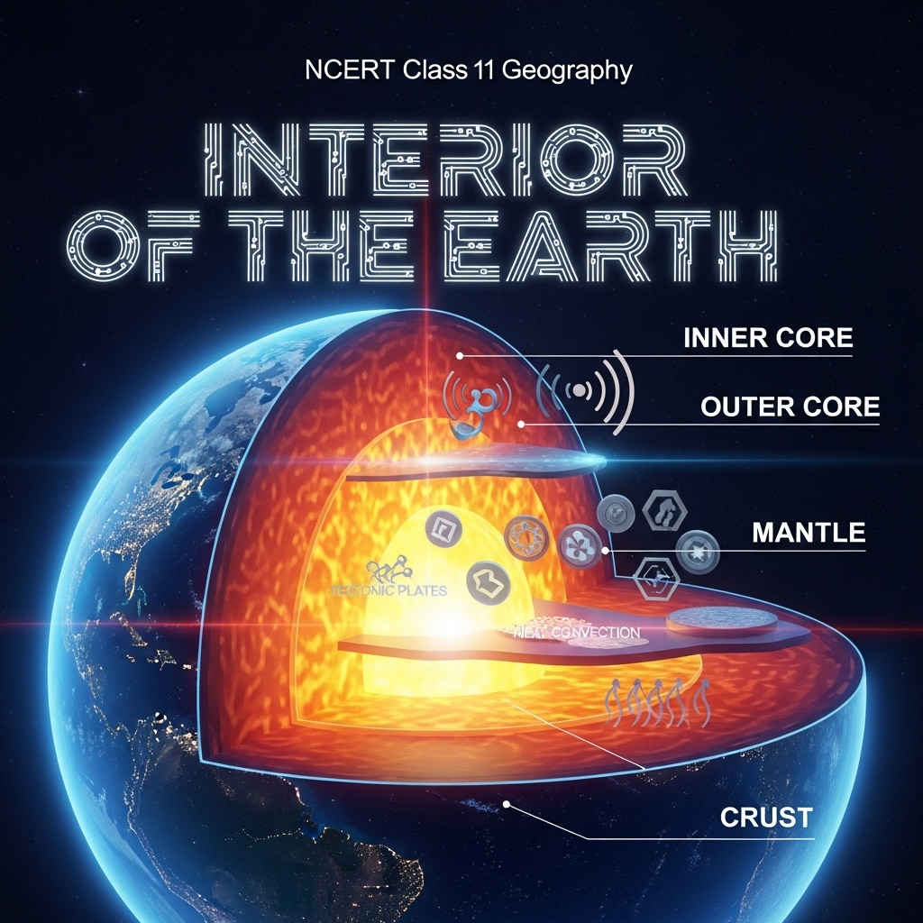
Structure of the Earth
Crust: Outermost brittle; oceanic 5 km, continental 30 km (70 km mountains). Mantle: To 2900 km; asthenosphere weak 400 km magma source; lithosphere crust+upper mantle 10-200 km; lower solid. Core: 2900 km boundary; outer liquid, inner solid; nife (nickel-iron). Expanded: Figure 3.3 layers. Crust silicon/aluminum; mantle magnesium; core iron density 13 g/cm³.
- Examples: Himalayan crust thick; Moho discontinuity.
- Point: Waves velocities indicate states.
- Expanded: Gutenberg core-mantle; Conrad crust types.
Extended: Discontinuities separate layers.
Volcanoes and Volcanic Landforms
Volcano: Gases/ashes/lava escape. Active recent. Mantle asthenosphere source; magma below, lava surface. Types: Shield (basalt fluid, Hawaiian), composite (viscous explosive, layers), caldera (collapse), flood basalt (fluid flows, Deccan). Mid-ocean ridge frequent. Expanded: Lava pyroclastic, bombs, dust, gases (nitrogen/sulphur/chlorine/hydrogen/argon).
- Examples: Hawaiian shield; Paricutin cinder.
- Point: Classified eruption/form.
- Expanded: Flood thousands km; Deccan Maharashtra.
Extended: Intrusive: Batholiths domes, lacoliths, lapoliths saucer, phacoliths wavy, sills/sheets horizontal, dykes vertical.
Summary
- Interior indirect; layers crust-mantle-core; earthquakes waves shadow; volcanoes types landforms.
Why This Guide Stands Out
Complete: All subtopics, examples, Q&A, quiz. Geography-focused. Free 2025.
Key Themes & Tips
- Aspects: Indirect inference, seismic analysis, volcanic processes.
- Thinkers: None specific; modern projects like Kola.
- Tip: Diagrams waves/shadow/layers; types classify; effects list.
Exam Case Studies
Deccan traps, tsunami 2004, shadow zones.
Project & Group Ideas
- Model earth layers.
- Debate earthquake preparedness.


As an Amazon Associate, ProSyllabus earns from qualifying purchases. Prices shown are subject to change.
Test your CBSE Class 11 Annual Assessment prep
Quizzes
10 questions · ~10 minutes · instant rank & AI diagnosis
Accountancy (Class 11) Practice Quiz | CBSE Class 11 Annual Assessment
Sets and Venn Operations Fundamentals — Free CBSE Class 11 Annual Assessment Quiz
Class 11 English — The Tale of Melon City (Practice Quiz)
Class 11 English — Birth (Practice Quiz)
Class 11 English — Mother's Day (Practice Quiz)
Class 11 English — The Address (Practice Quiz)
Class 11 English — The Summer of the Beautiful White Horse (Practice Quiz)
Class 11 English — Father to Son (Practice Quiz)
Class 11 English — Silk Road (Practice Quiz)
Class 11 English — The Adventure (Practice Quiz)
Class 11 English — Childhood (Practice Quiz)
Class 11 English — The Ailing Planet: the Green Movement's Role (Practice Quiz)
Class 11 English — The Voice of the Rain (Practice Quiz)
Class 11 English — The Laburnum Top (Practice Quiz)
Class 11 English — Discovering Tut: the Saga Continues (Practice Quiz)
Class 11 English — We're Not Afraid to Die... if We Can All Be Together (Practice Quiz)
Class 11 English — A Photograph (Practice Quiz)
Class 11 English — The Portrait of a Lady (Practice Quiz)
Class 11 Psychology — Motivation and Emotion (Practice Quiz)
Class 11 Psychology — Thinking (Practice Quiz)
Class 11 Psychology — Human Memory (Practice Quiz)
Class 11 Psychology — Learning (Practice Quiz)
Class 11 Psychology — Sensory, Attentional and Perceptual Processes (Practice Quiz)
Class 11 Psychology — Human Development (Practice Quiz)
Class 11 Psychology — Methods of Enquiry in Psychology (Practice Quiz)
Class 11 Psychology — What is Psychology? (Practice Quiz)
Class 11 Sociology — Indian Sociologists (Practice Quiz)
Class 11 Sociology — Introducing Western Sociologists (Practice Quiz)
Class 11 Sociology — Environment and Society (Practice Quiz)
Class 11 Sociology — Social Change and Social Order in Rural and Urban Society (Practice Quiz)
Class 11 Sociology — Social Structure, Stratification and Social Processes in Society (Practice Quiz)
Class 11 Sociology — Doing Sociology: Research Methods (Practice Quiz)
Class 11 Sociology — Culture and Socialisation (Practice Quiz)
Class 11 Sociology — Understanding Social Institutions (Practice Quiz)
Class 11 Sociology — Terms, Concepts and Their Use in Sociology (Practice Quiz)
Class 11 Sociology — Sociology and Society (Practice Quiz)
Class 11 Political Science — The Philosophy of the Constitution (Practice Quiz)
Class 11 Political Science — Constitution as a Living Document (Practice Quiz)
Class 11 Political Science — Local Governments (Practice Quiz)
Class 11 Political Science — Federalism (Practice Quiz)
Class 11 Political Science — Judiciary (Practice Quiz)
Class 11 Political Science — Legislature (Practice Quiz)
Class 11 Political Science — Executive (Practice Quiz)
Class 11 Political Science — Election and Representation (Practice Quiz)
Class 11 Political Science — Rights in the Indian Constitution (Practice Quiz)
Class 11 Political Science — Constitution: Why and How? (Practice Quiz)
Class 11 Political Science — Secularism (Practice Quiz)
Class 11 Political Science — Nationalism (Practice Quiz)
Class 11 Political Science — Citizenship (Practice Quiz)
Class 11 Political Science — Rights (Practice Quiz)
Class 11 Political Science — Social Justice (Practice Quiz)
Class 11 Political Science — Equality (Practice Quiz)
Class 11 Political Science — Freedom (Practice Quiz)
Class 11 Political Science — Political Theory: An Introduction (Practice Quiz)
Class 11 Geography — Natural Hazards and Disasters (Practice Quiz)
Class 11 Geography — Natural Vegetation (Practice Quiz)
Class 11 Geography — Climate (Practice Quiz)
Class 11 Geography — Drainage System (Practice Quiz)
Class 11 Geography — Structure and Physiography (Practice Quiz)
Class 11 Geography — India – Location (Practice Quiz)
Class 11 Geography — Biodiversity and Conservation (Practice Quiz)
Class 11 Geography — Movements of Ocean Water (Practice Quiz)
Class 11 Geography — Water (Oceans) (Practice Quiz)
Class 11 Geography — World Climate and Climate Change (Practice Quiz)
Class 11 Geography — Water in the Atmosphere (Practice Quiz)
Class 11 Geography — Atmospheric Circulation and Weather Systems (Practice Quiz)
Class 11 Geography — Solar Radiation, Heat Balance and Temperature (Practice Quiz)
Class 11 Geography — Composition and Structure of Atmosphere (Practice Quiz)
Class 11 Geography — Landforms and their Evolution (Practice Quiz)
Class 11 Geography — Geomorphic Processes (Practice Quiz)
Class 11 Geography — Distribution of Oceans and Continents (Practice Quiz)
Class 11 Geography — Interior of the Earth (Practice Quiz)
Class 11 Geography — The Origin and Evolution of the Earth (Practice Quiz)
Class 11 Geography — Geography as a Discipline (Practice Quiz)
Class 11 History — Paths to Modernisation (Practice Quiz)
Class 11 History — Displacing Indigenous Peoples (Practice Quiz)
Class 11 History — Changing Cultural Traditions (Practice Quiz)
Class 11 History — The Three Orders (Practice Quiz)
Class 11 History — Nomadic Empires (Practice Quiz)
Class 11 History — An Empire Across Three Continents (Practice Quiz)
Class 11 History — Writing and City Life (Practice Quiz)
Class 11 Economics — Comparative Development Experiences of India and its Neighbours (Practice Quiz)
Class 11 Economics — Environment and Sustainable Development (Practice Quiz)
Class 11 Economics — Employment: Growth, Informalisation and Other Issues (Practice Quiz)
Class 11 Economics — Rural Development (Practice Quiz)
Class 11 Economics — Human Capital Formation in India (Practice Quiz)
Class 11 Economics — Liberalisation, Privatisation and Globalisation: An Appraisal (Practice Quiz)
Class 11 Economics — Indian Economy 1950-1990 (Practice Quiz)
Class 11 Economics — Indian Economy on the Eve of Independence (Practice Quiz)
Class 11 Economics — Use of Statistical Tools (Practice Quiz)
Class 11 Economics — Index Numbers (Practice Quiz)
Class 11 Economics — Correlation (Practice Quiz)
Class 11 Economics — Measures of Central Tendency (Practice Quiz)
Class 11 Economics — Presentation of Data (Practice Quiz)
Class 11 Economics — Organisation of Data (Practice Quiz)
Class 11 Economics — Collection of Data (Practice Quiz)
Class 11 Economics — Introduction (Practice Quiz)
Class 11 Business Studies — International Business (Practice Quiz)
Class 11 Business Studies — Internal Trade (Practice Quiz)
Class 11 Business Studies — MSME and Business Entrepreneurship (Practice Quiz)
Class 11 Business Studies — Sources of Business Finance (Practice Quiz)
Class 11 Business Studies — Formation of a Company (Practice Quiz)
Class 11 Business Studies — Social Responsibilities of Business and Business Ethics (Practice Quiz)
Class 11 Business Studies — Emerging Modes of Business (Practice Quiz)
Class 11 Business Studies — Business Services (Practice Quiz)
Class 11 Business Studies — Private, Public and Global Enterprises (Practice Quiz)
Class 11 Business Studies — Forms of Business Organisation (Practice Quiz)
Class 11 Business Studies — Business, Trade and Commerce (Practice Quiz)
Class 11 Accountancy — Financial Statements - II (Practice Quiz)
Class 11 Accountancy — Financial Statements - I (Practice Quiz)
Class 11 Accountancy — Depreciation, Provisions and Reserves (Practice Quiz)
Class 11 Accountancy — Trial Balance and Rectification of Errors (Practice Quiz)
Class 11 Accountancy — Bank Reconciliation Statement (Practice Quiz)
Class 11 Accountancy — Recording of Transactions - II (Practice Quiz)
Class 11 Accountancy — Recording of Transactions - I (Practice Quiz)
Class 11 Accountancy — Theory Base of Accounting (Practice Quiz)
Class 11 Accountancy — Introduction to Accounting (Practice Quiz)
Class 11 Maths — Probability (Practice Quiz)
Class 11 Maths — Statistics (Practice Quiz)
Class 11 Maths — Limits and Derivatives (Practice Quiz)
Class 11 Maths — Introduction to Three Dimensional Geometry (Practice Quiz)
Class 11 Maths — Conic Sections (Practice Quiz)
Class 11 Maths — Straight Lines (Practice Quiz)
Class 11 Maths — Sequences and Series (Practice Quiz)
Class 11 Maths — Binomial Theorem (Practice Quiz)
Class 11 Maths — Permutations and Combinations (Practice Quiz)
Class 11 Maths — Linear Inequalities (Practice Quiz)
Class 11 Maths — Complex Numbers and Quadratic Equations (Practice Quiz)
Class 11 Maths — Relations and Functions (Practice Quiz)
Class 11 Maths — Sets (Practice Quiz)
Class 11 Biology — Chemical Coordination and Integration (Practice Quiz)
Class 11 Biology — Neural Control and Coordination (Practice Quiz)
Class 11 Biology — Locomotion and Movement (Practice Quiz)
Class 11 Biology — Excretory Products and their Elimination (Practice Quiz)
Class 11 Biology — Body Fluids and Circulation (Practice Quiz)
Class 11 Biology — Breathing and Exchange of Gases (Practice Quiz)
Class 11 Biology — Plant Growth and Development (Practice Quiz)
Class 11 Biology — Respiration in Plants (Practice Quiz)
Class 11 Biology — Photosynthesis in Higher Plants (Practice Quiz)
Class 11 Biology — Cell Cycle and Cell Division (Practice Quiz)
Class 11 Biology — Biomolecules (Practice Quiz)
Class 11 Biology — Cell: The Unit of Life (Practice Quiz)
Class 11 Biology — Structural Organisation in Animals (Practice Quiz)
Class 11 Biology — Anatomy of Flowering Plants (Practice Quiz)
Class 11 Biology — Morphology of Flowering Plants (Practice Quiz)
Class 11 Biology — Animal Kingdom (Practice Quiz)
Class 11 Biology — Plant Kingdom (Practice Quiz)
Class 11 Biology — Biological Classification (Practice Quiz)
Class 11 Biology — The Living World (Practice Quiz)
Class 11 Chemistry — Hydrocarbons (Practice Quiz)
Class 11 Chemistry — Organic Chemistry – Some Basic Principles and Techniques (Practice Quiz)
Class 11 Chemistry — Redox Reactions (Practice Quiz)
Class 11 Chemistry — Equilibrium (Practice Quiz)
Class 11 Chemistry — Chemical Bonding and Molecular Structure (Practice Quiz)
Class 11 Chemistry — Classification of Elements and Periodicity in Properties (Practice Quiz)
Class 11 Chemistry — Some Basic Concepts of Chemistry (Practice Quiz)
Class 11 Physics — Waves (Practice Quiz)
Class 11 Physics — Oscillations (Practice Quiz)
Class 11 Physics — Kinetic Theory (Practice Quiz)
Class 11 Chemistry — Thermodynamics (Practice Quiz)
Class 11 Physics — Thermal Properties of Matter (Practice Quiz)
Class 11 Physics — Mechanical Properties of Fluids (Practice Quiz)
Class 11 Physics — Mechanical Properties of Solids (Practice Quiz)
Class 11 Physics — Gravitation (Practice Quiz)
Class 11 Physics — Systems of Particles and Rotational Motion (Practice Quiz)
Class 11 Physics — Work, Energy and Power (Practice Quiz)
Class 11 Physics — Motion in a Plane (Practice Quiz)
Class 11 Physics — Motion in a Straight Line (Practice Quiz)
Class 11 Physics — Units and Measurement (Practice Quiz)
Class 11 Maths — Trigonometric Functions (Practice Quiz)
Class 11 Chemistry — Structure of Atom (Practice Quiz)
Class 11 Physics — Laws of Motion (Practice Quiz)
Business Studies (Class 11) Practice Quiz | CBSE Class 11 Annual Assessment
Economics (Class 11) Practice Quiz | CBSE Class 11 Annual Assessment
Humanities Subjects Practice Quiz | CBSE Class 11 Annual Assessment
Motion in a Straight Line Practice Quiz | CBSE Class 11 Annual Assessment
Thermodynamic Processes and Laws Advanced Challenge | CBSE Class 11 Annual Assessment

Group Discussions
No forum posts available.

