Complete Solutions and Summary of Physical Features of India – NCERT Class 9, Geography, Chapter 2 – Summary, Questions, Answers, Extra Questions
Detailed summary and explanation of Chapter 2 ‘Physical Features of India’ covering the Himalayan mountains, Northern plains, Peninsular plateau, Indian desert, Coastal plains, and Islands, their formation, characteristics, and significance with all question answers, map skills, and extra questions from NCERT Class IX Geography.
Updated: 9 months ago
Physical Features of India
Chapter 2: Geography - Complete Study Guide | NCERT Class 9 Notes & Questions 2025
Comprehensive Chapter Summary - Physical Features of India Class 9 NCERT
Overview
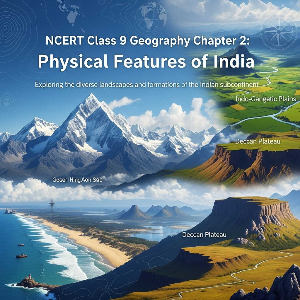
- Chapter Purpose: Explains India's diverse physical features: mountains, plains, deserts, plateaus, islands. Varied landforms from vast stretches of plain land to rugged terrain with mountains and valleys. In fact, India has practically all major physical features of the earth. The land displays great physical variation, with geological differences: Peninsular Plateau as one of the ancient landmasses, supposed to be stable; Himalayas and Northern Plains as recent landforms, with Himalayas being unstable zone with youthful topography including high peaks, deep valleys, fast flowing rivers. Northern Plains formed of alluvial deposits, Peninsular Plateau of igneous and metamorphic rocks with gently rising hills and wide valleys. Key Insight: These features complement each other, making the country richer in natural resources—mountains for water and forests, plains for agriculture, plateau for minerals, coasts and islands for fishing and ports.
- Major Divisions: Grouped under six physiographic divisions (Figure 2.2: Relief): (1) Himalayan Mountains, (2) Northern Plains, (3) Peninsular Plateau, (4) Indian Desert, (5) Coastal Plains, (6) Islands. Each division has unique characteristics contributing to India's geography. Figure 2.1: Himalayas map showing ranges and peaks.
- Himalayan Mountains (Expanded): Geologically young and structurally fold mountains stretching over northern borders from Indus to Brahmaputra in west-east direction, forming an arc of about 2,400 km. Width varies from 400 km in Kashmir to 150 km in Arunachal Pradesh. Altitudinal variations greater in eastern half. Consists of three parallel ranges: Great or Inner Himalayas (Himadri)—most continuous, loftiest peaks avg 6,000 m, asymmetrical folds, granite core, perennially snow-bound, glaciers descend; Lesser Himalaya (Himachal)—rugged, compressed/altered rocks, altitude 3,700-4,500 m, avg width 50 km, prominent ranges like Pir Panjal (longest), Dhaula Dhar, Mahabharat, famous valleys Kashmir, Kangra, Kullu, hill stations; Outer Himalayas (Shiwaliks)—width 10-50 km, altitude 900-1,100 m, unconsolidated sediments, thick gravel/alluvium in valleys called Duns (Dehra Dun, Kotli Dun, Patli Dun). Besides longitudinal, divided regionally: Punjab Himalaya (Indus-Satluj, known as Kashmir/Himachal), Kumaon (Satluj-Kali), Nepal (Kali-Teesta), Assam (Teesta-Dihang). Beyond Dihang gorge, bend south to Purvachal or Eastern hills/mountains (Patkai, Naga, Manipur, Mizo hills)—sedimentary sandstones, dense forests, parallel ranges/valleys. Figure 2.3: The Himalayas; Figure 2.4: Mizo Hills. Peaks list: Mt. Everest (Nepal, 8848 m), Kanchenjunga (India, 8598 m), etc.
- Northern Plains (Expanded): Formed by interplay of Indus, Ganga, Brahmaputra and tributaries, alluvial soil deposited in vast basin at Himalayan foothills over millions of years—area 7 lakh sq km, 2400 km long, 240-320 km broad, densely populated, agriculturally productive due to rich soil, water, climate. Rivers from mountains do depositional work; lower course gentle slope decreases velocity, forms riverine islands (e.g., Majuli largest inhabited in Brahmaputra). Divided into Punjab Plains (Indus tributaries, doabs, larger part Pakistan—Jhelum, Chenab, Ravi, Beas, Satluj), Ganga Plain (Ghaggar-Teesta, Haryana/Delhi/UP/Bihar/part Jharkhand/West Bengal), Brahmaputra Plain (Assam). Not flat—diverse relief: Bhabar (8-16 km pebble belt parallel Shiwaliks, streams disappear), Terai (south, wet/swampy/marshy, thick forests/wildlife cleared for agriculture, Dudhwa Park), Bhangar (older alluvium above floodplains, terrace-like, calcareous kankar), Khadar (newer younger floodplains renewed yearly, fertile for intensive agriculture). Distributaries in lower course from silt. Doab from 'do' (two) 'ab' (water); Punjab 'punj' (five) 'ab'.
- Peninsular Plateau (Expanded): Tableland of old crystalline, igneous, metamorphic rocks from breaking/drifting Gondwana land, oldest landmass with broad/shallow valleys, rounded hills. Two divisions: Central Highlands (north Narmada, major Malwa plateau, bounded Satpura south/Aravalis northwest, merges Rajasthan desert; rivers Chambal/Sind/Betwa/Ken southwest-northeast slope; wider west, narrower east; eastward Bundelkhand/Baghelkhand, further Chotanagpur drained Damodar), Deccan Plateau (triangular south Narmada, Satpura base north, Mahadev/Kaimur/Maikal eastern extensions; higher west slopes east; northeast Meghalaya/Karbi-Anglong/North Cachar separated fault; hill ranges Garo/Khasi/Jaintia). Western Ghats (parallel western coast, continuous, crossed passes Thal/Bhor/Pal, avg 900-1600 m, cause orographic rain, height increases south, peaks Anai Mudi 2695 m/Doda Betta 2637 m, local names), Eastern Ghats (Mahanadi Valley to Nilgiris south, discontinuous/irregular/dissected rivers to Bay Bengal, peaks Mahendragiri 1501 m, Shevroy/Javadi southeast, hill stations Ooty/Kodaikanal). Deccan Trap black soil volcanic origin, igneous rocks denuded. Aravali Hills western/northwestern margins, highly eroded/broken, Gujarat-Delhi southwest-northeast. Figure 2.6: A Waterfall in Chotanagpur Plateau.
- Indian Desert (Expanded): Lies towards western margins Aravali Hills, undulating sandy plain with sand dunes, receives very low rainfall below 150 mm per year, arid climate low vegetation. Streams appear rainy season, disappear sand not enough water to sea. Luni only large river. Barchans (crescent-shaped dunes) cover larger areas, longitudinal dunes more prominent near Indo-Pakistan boundary—visit Jaisalmer for barchans group. Figure 2.7: The Indian Desert.
- Coastal Plains (Expanded): Peninsular plateau flanked by narrow coastal strips along Arabian Sea west/Bay Bengal east. Western coast sandwiched Western Ghats/Arabian Sea narrow plain: northern Konkan (Mumbai-Goa), central Kannad Plain, southern Malabar coast. Plains along Bay Bengal wide/level: northern Northern Circar, southern Coromandel Coast. Large rivers Mahanadi/Godavari/Krishna/Kaveri formed extensive deltas. Lake Chilika important feature eastern coast, largest salt water lake India, Odisha south Mahanadi delta. Figure 2.8: The Coastal Plains.
- Islands (Expanded): Besides vast mainland, two groups: Lakshadweep (close Malabar coast Kerala, small coral islands, earlier Laccadive/Minicoy/Amindive, renamed 1973, 32 sq km, Kavaratti administrative HQ, great diversity flora/fauna, Pitti uninhabited bird sanctuary), Andaman and Nicobar (elongated chain Bay Bengal north-south, bigger/more numerous/scattered, divided Andaman north/Nicobar south, elevated submarine mountains, great strategic importance, diversity flora/fauna, close equator equatorial climate thick forest cover, India's only active volcano Barren Island Andaman Nicobar group). Corals: Short-lived microscopic organisms live colonies shallow mud-free warm waters, secrete calcium carbonate form reefs—three kinds: barrier reef (e.g., Great Barrier Reef Australia), fringing reef, atolls (circular/horse shoe-shaped). Figure 2.9: An Island.
- Expanded Relevance 2025: Emphasizes resource complementarity and future development possibilities. With climate change, focus on impacts like Himalayan instability, desert expansion, coastal erosion. Update: Sustainable practices for each feature, e.g., conservation in Terai, mining regulations in plateau.
- Exam Tip: Memorize divisions, sub-parts; use figures for map questions; distinguish features like Ghats, alluvium types.
- Broader Implications: Diverse features support biodiversity, economy; unstable zones prone to earthquakes/floods need disaster management.
SEO Note: Why This Guide?
Top-ranked for 'Physical Features of India Class 9 notes 2025'—free, with 60 Q&A from PDF, quizzes. Integrates geological insights.
Key Themes
- Geological Variations: Ancient/stable vs young/unstable landforms.
- Divisions Details: Formations, characteristics, economic roles. Figure 2.2: Relief map.
- Resource Links: Complementary for development.
- Regional Names: Punjab Himalaya, Purvachal, etc.
- Critical Thinking: Why Himalayas unstable? How plateau aids industrialization? Impact of alluvium on agriculture.
Cases for Exams
Use Figure 2.2 for relief identification; discuss alluvium formation and its fertility; analyze dune types in desert.
Exercises Summary
- Focus: Expanded to 60 Q&A from PDF: 20 short (2M), 20 medium (4M), 20 long (8M) based on NCERT exercises + similar.
- Project Idea: Puzzle for features; map marking of peaks, ranges, plateaus.


As an Amazon Associate, ProSyllabus earns from qualifying purchases. Prices shown are subject to change.
Test your CBSE Class 9 Annual Assessment prep
Quizzes
10 questions · ~10 minutes · instant rank & AI diagnosis
Class 9 Science — Tissues in Action (Practice Quiz)
Class 9 Hindi — तब याद तुम्हारी आती है (Practice Quiz)
Class 9 Hindi — निर्मल जीत सिंह सेखों (Practice Quiz)
Class 9 Hindi — घर की याद (Practice Quiz)
Class 9 Hindi — झाँसी की रानी (Practice Quiz)
Class 9 Hindi — भारति, जय, विजयकरे! (Practice Quiz)
Class 9 Hindi — राम-लक्ष्मण-परशुराम संवाद (Practice Quiz)
Class 9 Hindi — रैदास के पद (Practice Quiz)
Class 9 Hindi — मैं और मेरा देश (Practice Quiz)
Class 9 Hindi — रीढ़ की हड्डी (Practice Quiz)
Class 9 Hindi — आखिरी चट्टान तक (Practice Quiz)
Class 9 Hindi — ऐसी भी बातें होती हैं (लता मंगेशकर से साक्षात्कार) (Practice Quiz)
Class 9 Hindi — संवादहीन (Practice Quiz)
Class 9 Hindi — क्या लिखूँ? (Practice Quiz)
Class 9 Hindi — दो बैलों की कथा (Practice Quiz)
Class 9 Physical Education — Yoga for Holistic Health and Personal Excellence (Practice Quiz)
Class 9 Physical Education — Sports (Practice Quiz)
Class 9 Physical Education — Sports for All (Practice Quiz)
Class 9 Physical Education — Olympism (Practice Quiz)
Class 9 Physical Education — Science and Sports (Practice Quiz)
Class 9 Physical Education — Physical Education and Well-being (Practice Quiz)
Class 9 English — Follow That Dream (Practice Quiz)
Class 9 English — Carrier of Words (Practice Quiz)
Class 9 English — Twin Melodies (Practice Quiz)
Class 9 English — The World of Limitless Possibilities (Practice Quiz)
Class 9 English — Vitamin-M (Practice Quiz)
Class 9 English — Winds of Change (Practice Quiz)
Class 9 English — The Pot Maker (Practice Quiz)
Class 9 English — How I Taught My Grandmother to Read (Practice Quiz)
Class 9 Maths — Predicting What Comes Next: Exploring Sequences and Progressions (Practice Quiz)
Class 9 Maths — The Mathematics of Maybe: Introduction to Probability (Practice Quiz)
Class 9 Maths — Measuring Space: Perimeter and Area (Practice Quiz)
Class 9 Maths — I'm Up and Down, and Round and Round (Practice Quiz)
Class 9 Maths — Exploring Algebraic Identities (Practice Quiz)
Class 9 Maths — The World of Numbers (Practice Quiz)
Class 9 Maths — Introduction to Linear Polynomials (Practice Quiz)
Class 9 Maths — Orienting Yourself: The Use of Coordinates (Practice Quiz)
Class 9 Science — Earth as a System: Energy, Matter, and Life (Practice Quiz)
Class 9 Science — Patterns in Life: Diversity and Classification (Practice Quiz)
Class 9 Science — Reproduction: How Life Continues (Practice Quiz)
Class 9 Science — Sound Waves: Characteristics and Applications (Practice Quiz)
Class 9 Science — Atomic Foundations of Matter (Practice Quiz)
Class 9 Science — Journey Inside the Atom (Practice Quiz)
Class 9 Science — Work, Energy, and Simple Machines (Practice Quiz)
Class 9 Science — How Forces Affect Motion (Practice Quiz)
Class 9 Science — Exploring Mixtures and their Separation (Practice Quiz)
Class 9 Science — Describing Motion Around Us (Practice Quiz)
Class 9 Science — Cell: The Building Block of Life (Practice Quiz)
Class 9 Science — Entering the World of Secondary Science (Practice Quiz)
Fundamental Rights and Duties Fundamentals | CBSE Class 9 Annual Assessment
Motion Along a Straight Line Fundamentals | CBSE Class 9 Annual Assessment
Number Systems and Operations Fundamentals — Free CBSE Class 9 Annual Assessment Quiz

Group Discussions
No forum posts available.

